R J Corman in Tennessee

boxcarwillie2

New Member
Hi everyone!! I noticed where someone was asking about RJ Corman layouts. That's how I found out about the web site. I'm presently building
a N scale layout at the whistle stop in Clarksville. I'm only 50% with it at
the present. Rj intersects with CSX in my layout in Liberty Falls.
Liberty Falls is a small community that has a track that circles the city.
This was a former L & N line from the south. CSX runs east and west and
can enter Liberty Falls from the east.
Liberty Falls is rich with revenue for RJ Corman with a mine, lumber yard,
and a beer brewery. A mini rail yard exists so cars can be switched with a
deticated former Santa Fe GP-38 whenever the need arises.
Corman has to contact CSX dispatch in Jacksonville to ask permission to
use the busy mainline. Corman has to travel one mile of mainline to get to
their main comming from the south.
I have 2 atlas R J Corman GP-38's. One is DCC, the other isn't. Only the
engines are offered in n scale. A whole set is offered in HO and can be purchased through RJ Corman's gift shop in Bardstown, Ky. This was a limited run so there may not be any left.
If you're looking for HO, I'll be listing a RJ Corman Athearns GP-38 on ebay
soon.
Thanks for reading and happy railroading!!!! Boxcar2
 

mcbane666

Member
welcome to the club, as a new member you most upload photo's of your layout (not really but i want to see anyway sign1)

Sounds like an interesting set up
 

Bill Nelson

Well-Known Member
RJ Corman RR

Boxcar,


I live in Cumberland heights, directly across the Cumberland from the Montgomery County courthouse, so the trestle approach to the swing bridge is directly in front of my front porch. before they tore down the T C, I could see seven railroad bridges from my front yard in the winter when the leaves were down.


My train club once considered trying to model Clarksville in N scale, I appointed myself to study the Cumberland river crossing, which I thought would be the make or break scene, and I think I discouraged them when I informed them that in N scale I'd need four feet for the east approach, and the three spans across the river.


Bill Nelson

old city ferry Rd. Clarksville Tn
 

Mountain Man

Active Member
Boxcar,


I live in Cumberland heights, directly across the Cumberland from the Montgomery County courthouse, so the trestle approach to the swing bridge is directly in front of my front porch. before they tore down the T C, I could see seven railroad bridges from my front yard in the winter when the leaves were down.


My train club once considered trying to model Clarksville in N scale, I appointed myself to study the Cumberland river crossing, which I thought would be the make or break scene, and I think I discouraged them when I informed them that in N scale I'd need four feet for the east approach, and the three spans across the river.


Bill Nelson

old city ferry Rd. Clarksville Tn

Four feet?! In N-scale?! :-o
 

Bill Nelson

Well-Known Member
four feet!

That bridge is humongousl! The plate girder east approach spans an embankment, and river side drive, a four lane road with a suicide lane in the middle. The turn bridge in the center of the span. has room on either side of it's central pier for a three wide barge lash up to pass. The through truss spans on either side are only slightly smaller that the central turn bridge.

I don't have any digital photos of the bridge on hand, but if you go to Google earth, and find downtown Clarksville-North and west of Nashville, on the Cumberland River, and not far from the kentucky border. The cumberland has a big bend oposite downtown, and the bridge is across the river near the center of the bend in the river


my house is the big one just south of the road that goes under the bridge.

Bill Nelson
 

Mountain Man

Active Member
That bridge is humongousl! The plate girder east approach spans an embankment, and river side drive, a four lane road with a suicide lane in the middle. The turn bridge in the center of the span. has room on either side of it's central pier for a three wide barge lash up to pass. The through truss spans on either side are only slightly smaller that the central turn bridge.

I don't have any digital photos of the bridge on hand, but if you go to Google earth, and find downtown Clarksville-North and west of Nashville, on the Cumberland River, and not far from the kentucky border. The cumberland has a big bend oposite downtown, and the bridge is across the river near the center of the bend in the river


my house is the big one just south of the road that goes under the bridge.

Bill Nelson

That must be some bridge...:cool:
 

Bill Nelson

Well-Known Member
some bridge

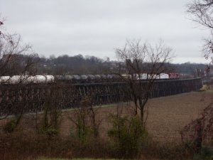
Here is a photo of the western approach, taken this morning. the main span is directly in line with the camera, which is about halfway down the bighill in my front yard.

The black truss above the line on the east side of the river is a remenient of the old TC the scrapper started to cut these up, but they were tougher than he figured.


There are two GP35s (my guess I don't do diseasels) the white blobs are spine cars carrying wallboard, and the tank cars are carrying sulfuric acid, a bi product from the local (cumberland height) Zink plant. The wallboard comes from Cumberland city.


The line was abannodoned past the zinc plant by the L &N. It used to go all the way to Memphis, but there was little local traffic, a steep grade halfway to Memphis, and this bridge, had a relatively light max load, and could not support locomotives that could pull big trains up that steem hill, so those three problems conjoined, doomed the Memphis line.

RJ Corman extended their line on the old right of way to Cumberland city, and built an industrial park. The sheetrock plant uses used gypsum that is used with the scrubbers on the big smokestacks at the big TVA coal fired Cumberland City power plant to reduce emmisions.


Bill Nelson
 

Attachments

  • trestle approach.jpg
    trestle approach.jpg
    152.5 KB · Views: 15

Bill Nelson

Well-Known Member
floodplain

Yes that is the river bottoms, directly across the river from Downtown Clarksville. The original bridge was much lower, about 25 feet lower. They had lots of accidents with steam boats, so extra stones were added to the piers (the joint in the stone work is clearly visible). that was done when the current bridge was built early in the last century.


back in those days the folks who lived @ my house owned 250 acres of river bottom land. they went broke, and sold off the good land. I have 21 acres, too rough to raise anything but goats!

Bill Nelson
 

Bill Nelson

Well-Known Member
bridge pictures

Here are some bridge pictures-- odd sized let me see if zealot will take them.


There they are! as I said, this is a big bridge. that's my house on the far right of the second photo


Bill Nelson
 

Attachments

  • SMLRJCbr1.jpg
    SMLRJCbr1.jpg
    79.1 KB · Views: 13
  • SMLRJCbr2.jpg
    SMLRJCbr2.jpg
    60.2 KB · Views: 10
Top