Limestone Canyon, Hell Canyon bridge and Drake field trip.

Ray Marinaccio

Active Member
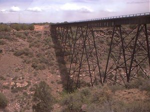
A few club members and I went on a field trip to Limestone Canyon, Hell Canyon bridge and Drake.
We followed some of the old Pea-Vine right of way up Limestone Canyon which is north of Paulden AZ. and west of Drake.
For anyone interested here are a couple of links to a brief history of the Pea-vine.
http://www.sharlot.org/archives/history/dayspast/text/1999_01_24.shtml
http://www.sharlot.org/archives/history/dayspast/text/1999_01_31.shtml

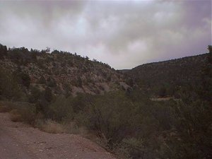
In the first photo the old right of way (the current road) can be seen along the hillside in this photo.
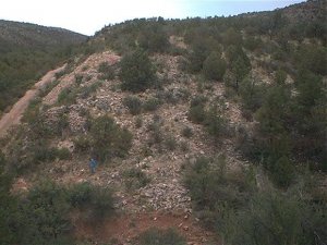
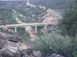
The second is one of the many gorges that were bridged by wood trestles.
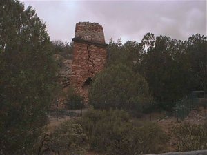
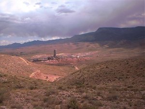
The third is one of the limestone kilns in the area.
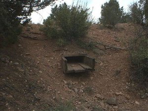
The fourth is a wooden culvert under the old right of way. It is over 100 years old.
 

Attachments

  • May22$05.JPG
    May22$05.JPG
    34.4 KB · Views: 107
  • May22$04.JPG
    May22$04.JPG
    55.2 KB · Views: 109
  • May22$02.JPG
    May22$02.JPG
    42.5 KB · Views: 113
  • May22$13.JPG
    May22$13.JPG
    66.1 KB · Views: 107

Ray Marinaccio

Active Member
Just south of Drake is the Hell Canyon bridge on the current BNSF line to Phoenix.
The first photo was taken from the south west side of the bridge.
The second photo is the abandoned highway 89 bridge just west of the railroad bridge.
On the north side of the bridge is Drake.
The third photo is the bridge from the north side just south of Drake. It looks small untill you get up to the canyon.
In the last photo you can see the foundation of the old wooden water tank and the replacement steel tank at Drake.
At Drake there is a wye and is where the tracks head east to Clarkdale for the Verde Canyon Railroad.
 

Attachments

  • May22$23.JPG
    May22$23.JPG
    65.6 KB · Views: 117
  • May22$16a.jpg
    May22$16a.jpg
    57.4 KB · Views: 106
  • May22$26.JPG
    May22$26.JPG
    42.5 KB · Views: 108

TrainNut

Ditat Deus
Neat stuff Ray. Back in about 1998 or so, some of Limestone canyon was on the US rally circuit. My wife and I went out there and watched the rally cars doing 100+ down some of those little dirt roads back in there. After that leg, they immediately drove over to Jerome and raced the old rail line from Jerome down to Perkinsville (or Perkins, I can't remember which it is called). Just up route 89 from Drake about another oh I'd say 2.5 miles on the West side is another set of bridges - one RR, one old highway. Don't know if you saw them or not but it makes a neat picture. To jog your memory if you did see it, there is a small (very small) lake/cow pond just opposite on the north side of the highway. My father and sisters have explored that area quite a bit on quads and he says that somewhere up in there, there is a bunch of mining equipment still surprisingly intact. Did you notice all of the Juniper trees? That area is supposed to be the largest stand of Jumiper trees in the United States.
 

Ray Marinaccio

Active Member
We didn't make it as far as Perkinsville. That sounds like a call for another field trip.
A couple of weeks ago we toured the cement plant at Clarkdale.
During the tour they took us up on the hill north of the plant to see their herd of buffalo.
 

Attachments

  • May17$16.JPG
    May17$16.JPG
    43.5 KB · Views: 90
  • May17$15.JPG
    May17$15.JPG
    52.1 KB · Views: 81

sbarton

New Member
Great photos Ray. Is the north end of the Hell's Canyon bridge hard to get to from Drake? I want to go see it but I don't have a 4 wheel drive and didn't know if I could drive in a regular car over to it or if I'd have to park at Drake and hike in.
 
Top