Looking for images of Woodford, California

nitnop3

New Member
Apr 20, 2003
4
0
1
71
Canada
Visit site
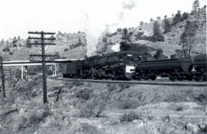
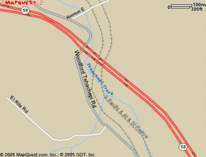
Hello. I'm in the planning stages for an N-scale module of the reverse curve on the former SP-ATSF line just west of Woodford, California (just west of the famous Tehachapi Loop). At this location, highway 58 crosses over the rail line. I've attached an image of that particular location. I have several photos taken at this location, but I'm particularly interested in what happens to the left side of the photo - ie what does the track / scenery look like, & where does the overpass / road go.

Any photos, illustrations or web locations pertaining this location would be greatly appreciated.

Thank you in advance.
 

Attachments

  • Cab forward 4289a.jpg
    Cab forward 4289a.jpg
    27.1 KB · Views: 120

CalFlash

Member
Oct 31, 2004
251
0
16
79
central Florida
You might want to contact the El Cajon club at the San Diego Museum who is doing a fabulous job of modeling Tehachapi and the area. I'm sure they have or can point you to pics that would be helpful in your modeling efforts. I don't know where you live, but if you ever have a chance to visit the club, do so. In the meantime, here is a link to some pics on the club: http://www.pbase.com/dh30973/lamesa&page=1

Dave's pics are a little more modeling orriented than layout - the first three links and a 4th on the bottom off http://community.webshots.com/user/atsf_arizona_layout_tour2 should give you more layout coverage.

Seems to me there's a book (Prototypes You Can Model?) that contains maps and pics of the area that might be useful.
 

jkristia

Member
Aug 1, 2002
426
0
16
56
Simi Valley, CA,
Visit site
I have been there a couple of time, but unfortunately I don't have any pictures from that particular location. As for how the track goes, this is from mapquest, don't know if that is any help

Jesper
 

Attachments

  • woordfordmap.gif
    woordfordmap.gif
    20.5 KB · Views: 101

nitnop3

New Member
Apr 20, 2003
4
0
1
71
Canada
Visit site
Thanks guys! Those locations were really helpful. By studying the topographical & aerial maps, I've got a good idea for what I'm looking for. Unfortunately I wasn't old enough to visit this location when the pictures were taken in the early 50's with Dad & my older brother Bill.